


This weather deserves a blue ribbon
Plus: The hottest temperature ever recorded in Columbus

The 614cast
Today’s tl;dr
🌤️ Patchy fog early, turning mostly sunny. Comfortable, high in the lower 80s.

Forecast highlights
🏆 Fantastic the next couple of days
The weather today and tomorrow are what we’ve been waiting for. The mugginess won’t be a pain in the butt (or a swamp in the same place, for that matter). Check out Tuesday morning — dew points in the 50s, something we haven’t enjoyed in foreverrrrr.
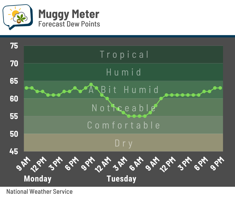
Okay, so technically Columbus did have a dew point that dipped into the upper 50s on the 8th, but that was only for the 7 p.m. observation… much of the day had dew points of 65–70, so it was a fairly humid day otherwise.
Otherwise, you have to go back to the beginning of the month to have a couple of days with a comfort level similar to this.
Oh, and lows might actually fall all the way to the lower 60s tomorrow morning. If that happens, it’ll be our coolest temperature in a month!

Basically, do what you can to spend some time outside today and tomorrow. This won’t last…
🌡️ Heating up again later this week
It’s not extreme heat, but we’ll certainly feel a change later this week. Highs on Wednesday will top out near 90 and come with a steady increase in mugginess throughout the day. Walking into work won’t feel too bad at all, but walking out at the end of the day? The stickiness will be back, and it’ll remain through the rest of the week.
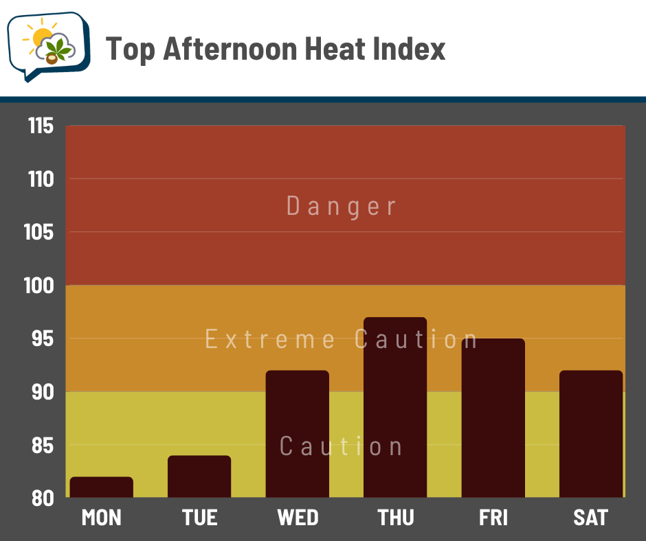
Peak heat indices Thursday and Friday should be around 95 or a smidge higher. That’s high enough that, if you’re spending a while outside, you’ll need to be mindful of preventing heat-related illness by taking more breaks and ensuring you’re hydrated.
🚫 Not as wet as originally thought
A few days ago, it looked like the ridge of high pressure aloft that was going to push the warmth back in would also be positioned to steer storm complexes in or near our region throughout the week.
That’s no longer the case, as the high pressure will positioned to shunt the storm track well to our north.
That ridge eventually breaks down late this week into next weekend, relaxing the heat and allowing rain chances to return.
📊 Today’s almanac
Normal low/high: 66 / 86
Record low/high: 48 (1970) / 106 (1934)
Sunrise/set: 6:21 a.m. / 8:55 p.m.
🔥 Columbus’ hottest temperature
On this date in 1934, the temperature in Columbus soared to 106 degrees — the hottest on record for the city.
That record was tied two years later on July 14, 1936, and has never been bested.
The 1930s were exceptionally hot in North America, especially in the central parts of the U.S. and Canada. Those Dust Bowl years were absolutely brutal, and numerous states’ all-time record highs from that era still stand. That includes Ohio’s: 113 in Gallipolis on this date in 1934.
Yale Climate Connections has a great summary of why it was so hot in the 1930s and puts it in the context of today’s climate.
Columbus had eight 100-degree days in 1934 and nine in 1936, for a grand total of 17 in those two years alone. We haven’t hit 100 since 2012 (logging four such days that summer, peaking at 101 on July 6 and 7).
It’s really hard to get past 100 degrees around here. Everything has to come together just right, and I’d say the most important factor is drought.
Here’s the national Drought Monitor map in early July 2012 when our last century-mark readings happened.

Ohio was mostly in moderate drought; we’ve certainly faced worse, even as recently as last summer. However, the expanse of drought across the country was huge, helping large areas bake and create a heat dome that sprawled even into places that weren’t crazy dry.
Drought begets drought, and the amped-up heat stymied appreciable rain. Extreme and exceptional drought expanded over the following month, although it largely spared Ohio.

🌭 Bonus weather weenie content
Climate catastrophes are creating a ‘new market reality’ for insurance carriers (CNN)
As flash floods rage, the tropical Atlantic stays mellow (Yale Climate Connections)